|
13 days
4276 km / 2657 miles
|
Early July 2018 Jayne
and I started on our Nevada motorcycle trip. Due to
work restraints (again) I had to do it July/August,
which is NOT the best time to ride in Nevada because
of the heat. We rode from Portland, Oregon south-east
to Prineville. From there we went further south-east
to Frenchglen,
where we had reserved a room at the historic
hotel. Further south on gravel roads over Steens Mountains
and on into Nevada. From Winnemucca we rode south to
Austin, NV but couldn't avoid a short stretch on I80.
In Austin we turned east and continued on Hwy 50, The Lonliest Road In
America, all the way to Great
Basin National Park. From there we rode
further south to Rachel,
NV, with a very short and unplanned trip to Las Vegas.
West again past Tonopah
and north towards Reno, but not actually going there.
We took a small road towards Gerlach,
NV, close to the site of Burning Man, which was a few
weeks after we passed through. Riding further north we
came trough a little bit of California
before entering Oregon again. We had planned to visit
Crater Lake again, but due to the heat and a wildfire
we skipped it, camped at Odell
Lake and then rode back home. On our
motorcycle trips we usually tent
camp most of the time, but on this trip we
stayed most nights in motels due to the overwhelming
heat during the day and little relieve at night.
|


|
The best time for such a trip is
NOT summer! Most days we had temperatures of around 100F
(38C), with the high near Las Vegas at 113F (45C). On
previous trips in Nevada we had experienced hot days
with very cold nights, but this time it barely cooled of
at night, so that we opted for air conditioned motels
most of the time.
The road conditions are generally good. Even
most of the gravel roads are in decend conditon. Paved
roads got very hot in the sun, therefore we rode with
higher tire pressure than normal to reduce the risk of
the tires overheating on our loaded down bikes.
In terms of safety wild animals and wildfires
are probably the greatest thread (besides other
drivers). Not only bears can be dangerous, but
mountain lions and even racoons can be dangerous.
We always left our food in locked aluminum
panniers when camping. In regards to wildfires
it is advisable to ask at ranger stations about
current conditions and expected fire direction. There
are also many phone apps out there to show wildfires,
but cell coverage in the middle of nowhere is spotty
at best.
|

|
I saw this in a travel guide for Nevada,
and it was true for most of our motorcycle trip.
|
 |
We left the interstate 5 near
Salem and rode east on highway 22 past Detroit
lake.
Later on
highway 20 we stopped to enjoy the view of Mt. Washington.
|

|
|
 |
| In Prineville, OR we turned south
on highway 27, which lead into a canyon,
with lots of campgrounds. |

|
|

|
We picked Palisades
Campground and got the best spot, at
the end of the lower level with some shade.
After we set up
camp we walked around a bit and enjoyed the
canyon and Crooked River.
|
 |
|

|
The next morning we continued
south on hwy 27, Crooked
River
Hwy. Nice, winding road.
About halfway
down the road turned into gravel,
well maintained with little washboard.
|

|
|
|
|
Motorcycle
aluminum
panniers and top cases
Made by an experienced
motorcycle traveller.
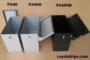
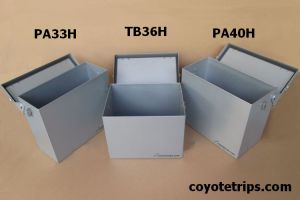

Panniers available in 47l, 40l and 33l
Top boxs available in 20l and 36l
Silver/Grey or Black
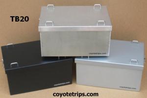
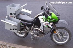
Quality is essential,
not only on a RTW tour.
|
|

